About Myself
I am an assistant professor at Virginia Tech, in the department
of civil and environmental engineering. I earned my bachelor of
science (BS) from Rensselaer Polytechnic Institute (RPI) in
civil engineering through coursework focused on geotechnical
engineering, structural engineering, and geology. Following my
undergraduate studies, I earned my MS and PhD from The
University of Texas at Austin (UT) under the supervision of
Brady R. Cox focusing on non-invasive 1D site characterization
methods using surface waves. Following my PhD I worked as a
research associate in the data intensive computing group
at the Texas Advanced Computing Center (TACC) before joining
the faculty at Virginia Tech.
About My Research
My research seeks to advance subsurface imaging
toward more robust and uncertainty-aware solutions through the
intersection of field experiments, numerical simulation, and
high-performance computing with applications in site
characterization, natural hazards, and infrastructure engineering.
Current Work
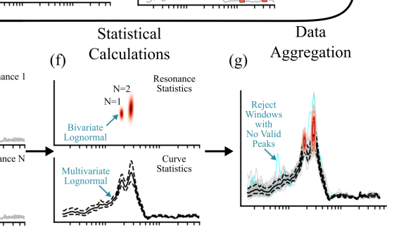
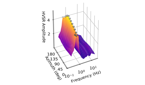
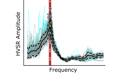
AutoHVSR: a machine-learning-supported algorithm for the fully-automated processing of horizontal-to-vertical spectral ratio measurements
(Vantassel et al., 2023)
The horizontal-to-vertical spectral ratio (HVSR) of ambient noise has seen widespread use as a tool for measuring a site's fundamental resonant frequency (f0).
However, the processing of HVSR with traditional methods can be tedious and time consuming, particularly when the HVSR is complex and exhibits multiple resonances.
This work proposes the AutoHVSR algorithm that allows for the fully-automated processing of HVSR measurements including those with zero, one, or multiple clear
resonances.
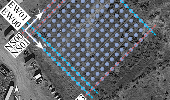
Subsurface Imaging Dataset Acquired at the Garner Valley Downhole Array Site using a Dense Network of Three-Component Nodal Stations
(Vantassel et al., 2023)
We present a large subsurface imaging dataset acquired using a dense network of
three-component (3C) nodal stations acquired in 2019 at the Garner Valley Downhole Array (GVDA) site. Acquisition of this
dataset involved the deployment of 196, 3C nodal stations positioned on a 14 by 14 grid with a 5-m spacing. The array was
used to acquire active-source data generated by a vibroseis truck and an instrumented sledgehammer, and passive-wavefield
data containing ambient noise.
Published Work
Selected Journal Publications
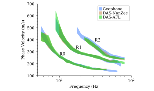
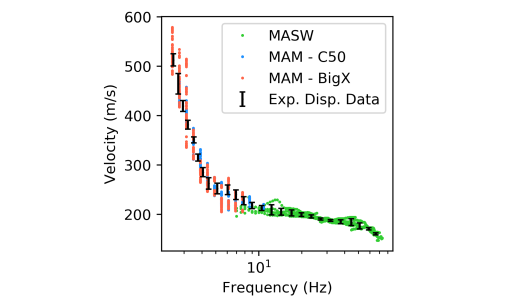
Extracting High-Resolution, Multi-Mode Surface Wave Dispersion Data from Distributed Acoustic Sensing Measurements using the Multichannel Analysis of Surface Waves
(Vantassel et al., 2022)
In this study, we rigorously assess the potential for extracting high-resolution, multi-mode surface wave dispersion
data from DAS measurements using active-source multichannel analysis of surface waves (MASW). This study demonstrates
that DAS, when appropriate considerations are made, can be used in-lieu of traditional sensors (i.e., geophones) for making
high-resolution, multi-mode measurements of surface wave dispersion data using the MASW technique.
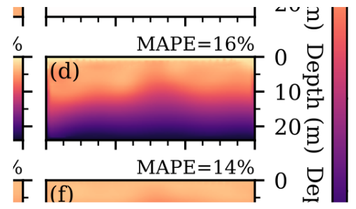
Using Convolutional Neural Networks to Develop Starting Models for 2D Full Waveform Inversion (Vantassel et al., 2021)
Non-invasive subsurface imaging using full waveform inversion (FWI) has the potential to fundamentally change engineering site
characterization by enabling the recovery of high resolution 2D/3D maps of subsurface stiffness. Yet, the accuracy of FWI remains
quite sensitive to the choice of the initial starting model due to the complexity and non-uniqueness of the inverse problem. In
response, we present the novel application of convolutional neural networks (CNNs) to transform an experimental seismic wavefield
acquired into a robust starting model for 2D FWI.

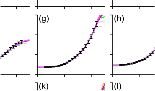
SWprocess: A Workflow for Developing Robust Estimates of Surface Wave Dispersion Uncertainty (Vantassel and Cox, 2021)
In comparison to invasive methods, non-invasive
surface wave methods suffer from highly variable standards of practice, with each company/group/analyst
estimating surface wave dispersion data, quantifying its uncertainty (or ignoring it in many cases),
and performing inversions to obtain Vs profiles in their own unique manner. In response, this work
presents a well-documented, production-tested, and easy-to-adopt workflow for developing estimates of
experimental surface wave dispersion data with robust measures of uncertainty.
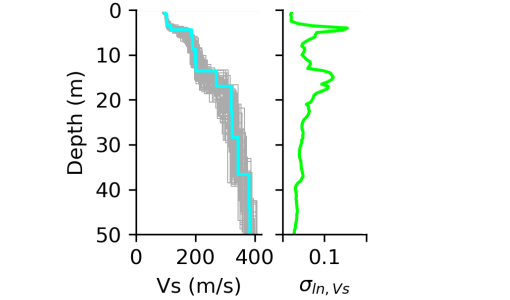
A Procedure for Developing Uncertainty-Consistent Vs Profiles from Inversion of Surface Wave Dispersion Data (Vantassel and Cox, 2021)
Non-invasive surface wave methods have become a popular alternative to traditional invasive forms of site characterization
for inferring a site's shear-wave velocity (Vs). However, the quantification and propagation of uncertainties
from surface wave measurements into the Vs profiles used in subsequent engineering analyses remains challenging.
In response, this paper presents an easy-to-implement, effective, and verifiable method for developing
uncertainty-consistent Vs profiles from inversion of surface wave dispersion data.
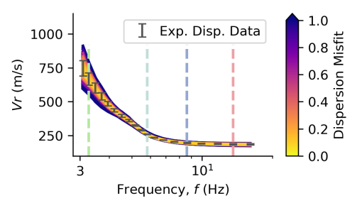
SWinvert: A Workflow for Rigorous Surface Wave Inversion (Vantassel and Cox, 2021)
SWinvert is a workflow for the inversion of surface wave dispersion data. SWinvert encourages analysts to
investigate inversion uncertainty and non-uniqueness in shear wave velocity (Vs) by providing a systematic
procedure and open-source tools for surface wave inversion. In particular, the workflow enables the use of
multiple layering parameterizations to address the inversion's non-uniqueness, multiple global searches for
each parameterization to address the inverse problem's non-linearity, and quantification of Vs uncertainty in the
resulting profiles.
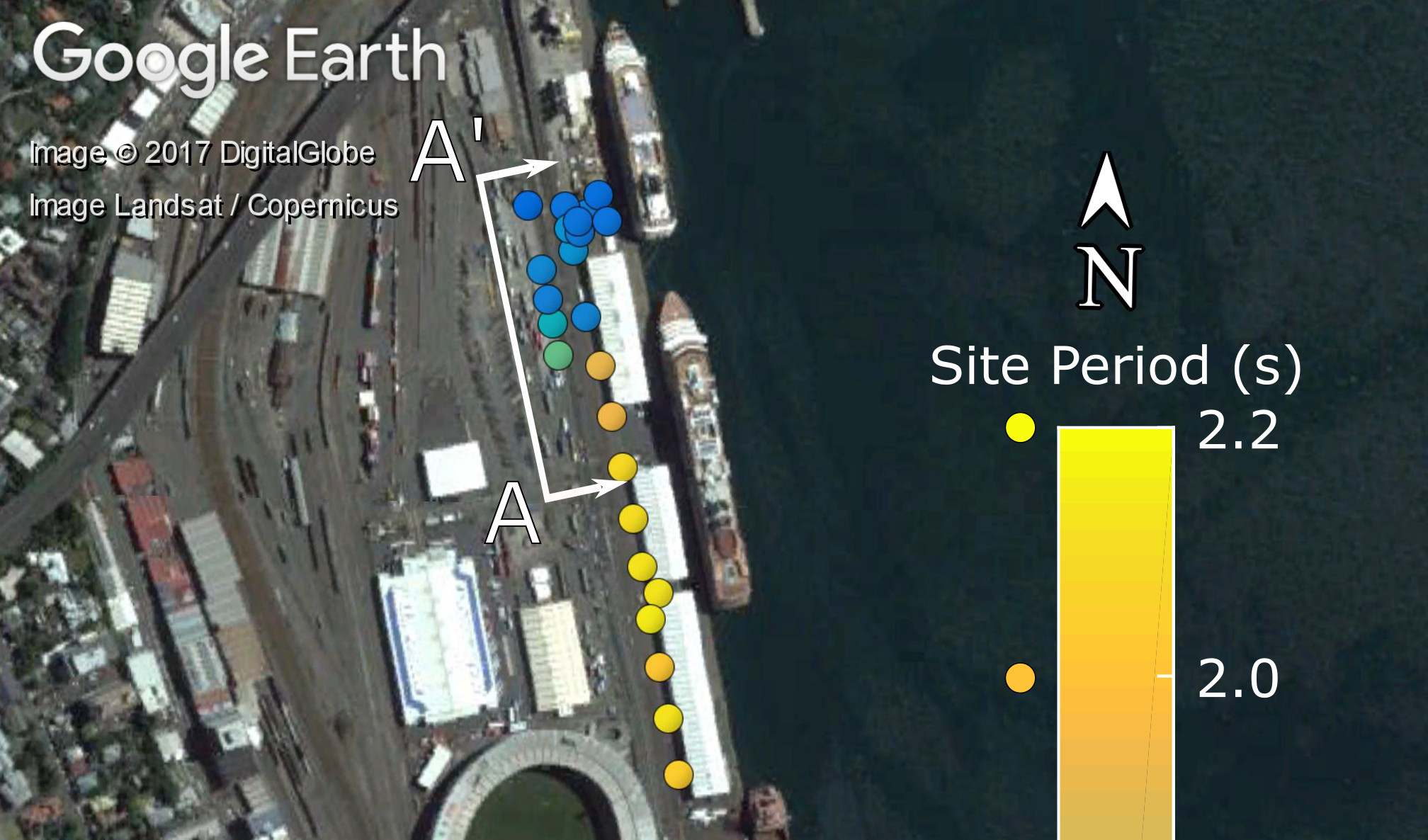
Mapping Depth to Bedrock, Shear Stiffness, and Fundamental Site Period at CentrePort, Wellington ... (Vantassel et al., 2018)
Wellington's port (CentrePort) experienced significant damage from the Mw 7.8 Kaikōura earthquake. To
propose mitigation measures to prevent similar damage in future earthquakes, there was a need to quantify
the port's depth to bedrock, shear stiffness, and fundamental site period (T0). The characterization effort
included horizontal-to-vertical (H/V) spectral ratio (HVSR) measurements and active-source and passive-wavefield
surface-wave measurements respectively.
Selected Conference Proceedings
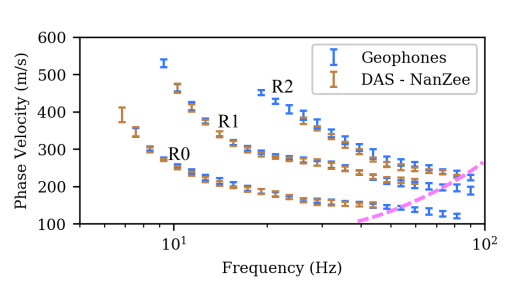
Effectiveness of Distributed Acoustic Sensing for Acquiring Surface Wave Dispersion Data using Multichannel Analysis of Surface Waves (Vantassel et al., 2022)
Distributed acoustic sensing (DAS) is a rapidly expanding tool to sense vibrations and system
deformations in many engineering applications. DAS presents the ability
to make static and dynamic strain measurements on a scale (e.g., kilometers), density (e.g., meter-scale),
and fidelity (e.g., microstrain) that was previously unattainable with traditional sensors.
This study demonstrates that DAS can be used in-lieu of traditional sensors
for making high-quality measurements of surface wave dispersion using the MASW technique.
Influence of different starting models on near-surface two-dimensional full waveform inversion (Vantassel et al., 2022)
FWI, as with all inverse problems, suffers from non-uniqueness, which results in multiple solutions
that may appear quite different to rank as equivalent in terms of the inverse problem's objective function.
Or in other words, multiple different potential solutions often fit the experimental data equally well, resulting
in uncertainty as to which is most representative of the subsurface. This paper examines uncertainty in the 2D FWI
inverse problem by considering how different starting models affect the accuracy of the solution
HVSRweb: An Open-Source, Web-Based Application for Horizontal-to-Vertical Spectral Ratio Processing (Vantassel et al., 2021)
The horizontal-to-vertical spectral ratio (HVSR) method has become an increasingly popular tool
for developing a quick and reliable estimate of a site's fundamental natural frequency. This
paper presents HVSRweb, an open-source, web-based application for performing HVSR
calculations in a convenient, reliable, and statistically-consistent manner.
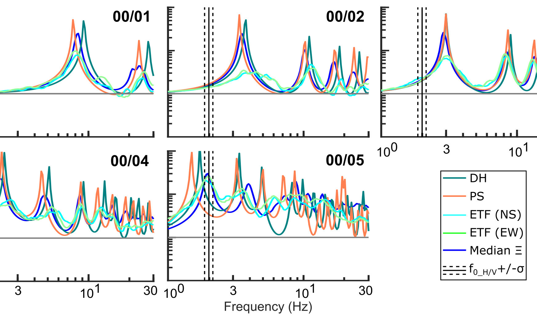
Multi-reference-depth Site Response at the Garner Valley Downhole Array (Vantassel and Cox, 2019)
Measured and predicted site response at the Garner Valley Downhole Array are compared using different reference depths/conditions.
Empirical transfer functions (ETFs) from small amplitude ground
motions are compared with 1D linear-viscoelastic theoretical transfer functions (TTFs) calculated using
shear wave velocity (Vs) profiles obtained from both invasive and non-invasive seismic testing.
Suites of non-invasive Vs profiles at the GVDA are shown to produce more accurate TTFs than those from
invasive Vs profiles for all reference depths/conditions.
Software
swprocess : A Python Package for Surface Wave Processing (Vantassel, 2021)
hvsrpy : An Open-Source Python Package for HVSR Processing (Vantassel, 2020)

swbatch : A DesignSafe-CI Application for Batch-Style Surface Wave Inversions (Vantassel et al., 2020)
swprepost : A Python Package for Surface Wave Inversion Pre- and Post-Processing (Vantassel, 2020)
sigpropy : A Python Package for Digital Signal Processing (Vantassel, 2020)
Published Data
- Vantassel, J. P., Cox, B. R., Crocker, J. (2023)
Active-Source and Passive-Wavefield 3-Component Nodal Station Measurements at the Garner Valley Downhole Array.
DesignSafe-CI [publisher]. https://doi.org/10.17603/ds2-ngdh-af80.
- Vantassel, J. P., Cox, B. R., Hubbard, P. G., Yust, M., & Menq, F. (2022)
Active-Source, Near-Surface, Surface-Wave Measurements using Distributed Acoustic Sensing (DAS) and Traditional Geophones [Dataset],
in Characterization of the NHERI@UTexas Hornsby Bend Test Site.
DesignSafe-CI [publisher]. https://doi.org/10.17603/ds2-bz52-ep82.
- Vantassel, J. P. & Cox, B. R. (2020)
Surface Wave Inversion Benchmarks [Dataset],
in Surface Wave Inversion Benchmarks.
DesignSafe-CI [publisher]. https://doi.org/10.17603/ds2-cpmr-v194.
- Cox, B.R, Spikes, K., Wood, C., Franke, K., Menq, F., Vantassel, J. P., Yust, M., & Stokoe, K. (2020).
NHERI@UTexas Proof-of-Capability Testing Workshop: non-intrusive 3D levee imaging in St. Louis, MO [Dataset].
DesignSafe-CI [publisher]. https://doi.org/10.17603/ds2-1zc5-8n08.
- Cox, B. R. & Vantassel, J. P. (2018) Dynamic Characterization of Wellington, New Zealand [Dataset].
DesignSafe-CI [publisher]. https://doi.org/10.17603/DS24M6J.
Technical Reports
- Cox, B.R., Vantassel, J.P. (2021). "Deep Shear Wave Velocity Profiling Using MASW and
MAM Surface Wave Methods: Idaho National Laboratory" Geotechnical Engineering Report GR21-03,
The University of Texas at Austin. May 2021.
- Cox, B.R., Vantassel, J.P., & Yust, M. (2021). "Deep Shear Wave Velocity Profiling Using MASW and
MAM Surface Wave Methods: Pantex Plant PSHA Site Investigation". Geotechnical Engineering
Report GR21-01, The University of Texas at Austin. January 2021.
- Cox, B.R. & Vantassel, J.P. (2019). "Deep Shear Wave Velocity Profiling Using MASW and MAM
Surface Wave Methods: Amarapura Urban Development Project (AUDP)". October 2019.
- Cox, B.R. & Vantassel, J.P. (2019). "Shear Wave Velocity Profiling Using MASW and MAM
Surface Wave Methods: Wellington Girls' College in Wellington, New Zealand". May 2019.
- Cox, B.R. & Vantassel, J.P. (2017). "Deep Shear Wave Velocity Profiling Using MASW and MAM
Surface Wave Methods: SCDOT Deep Borehole Sites near Andrews and Conway, South Carolina",
Geotechnical Engineering Report GR17-18, The University of Texas at Austin. July 2017.
- Cox, B.R., Teague, D., Vantassel, J.P. & Yust, M. (2017). “Deep Shear Wave Velocity Profiling Using MASW and
MAM Measurements: East Bay Municipal Utility District (EBMUD) Delta Tunnel
Project,” Geotechnical Engineering Report GR17-04, The University of Texas at Austin.
January 2017.
Open Access Course Material
An introduction to parallel programming.

An introduction to Git and version control.

A non-traditional approach to Python 3.

An introduction to the Bourne Again SHell (BASH).